
A couple of weeks ago on Mapping Monday I argued that topographic maps were cultural artefacts designed by the military, encoded with colonialist and masculinist messages, and not at all the sort of things we should consider as material for fantasy maps (or for any maps, in my opinion).
So what alternatives are there? Not many, it turns out. Topographic maps are one of three types of modern maps upon which western society depends, and the other two types are equally flawed. Today we’ll look at cadastral maps.
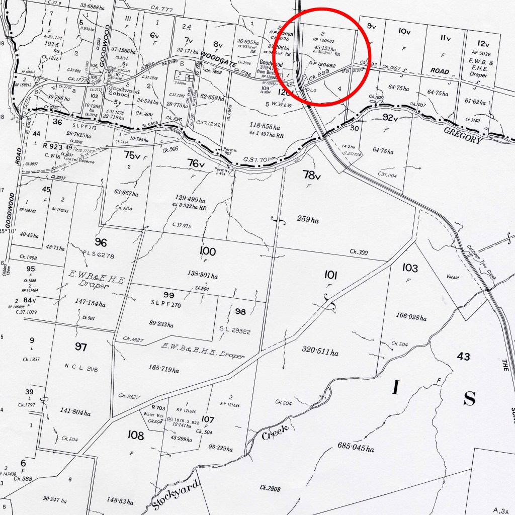
Cadastral maps are graphical records of property boundaries. Originally recorded on paper, they have since been digitised, and contain details of land area and location of key survey points. Look at the detail recorded for the property in the red circle above. Our society depends upon this knowledge.
Cadastral maps are based on the notion that land is a commodity that can be bought and sold. Of course, many cultures do not see land this way, instead viewing the earth as a life-partner rather than a currency to be traded. Nevertheless, the idea of the cadastre has been exported around the globe as a lieutenant of capitalism, and western property rights are based upon it.
Whenever I think of the cadastre I see a butcher’s knife cutting up a carcass, red lines springing up on newly-dead flesh.
I think of the western grid of streets (north, south, east west) lowered on to indigenous spaces, imprisoning the land under its dead weight. Go to any town or city, large or small, built around the world during the colonial period, and see town plans dropped on the landscape with no regard for physical or cultural reality.
Tell you a story. The centre of Christchurch is just such a grid, based on the cardinal directions, a series of north/south/east/west streets inside the square Four Avenues. It’s interrupted by the Avon River in places, but the grid is clear. Swamps, rushes, lakes, urupa (grave sites) and sand dunes are all imprisoned under the grid.
Move forward to 2011 and the Christchurch earthquake. Most of the 185 deaths came from two building collapses, one due to poor architecture. The other, however, was found to have been built on an old stream bed feeding into the Avon River. The ground collapsed inwards towards the centre of the stream, taking the building with it. That is a steep price to be paid for impositional cartography, ignoring reality and imposing your own brand of ‘order’ on what you see as a moral wilderness. Of course it’s usually indigenous cultures who pay the price of such thinking, but we seldom hear their stories.

A story like this illustrates how fraught cartography is, yet our fantasy maps reflect none of this complexity – at least, not deliberately. Next week I’ll talk about the third common kind of western cartography, thematic maps, and ask if they’d be any better at the task of reflecting our desired values.

Leave a comment